Meesapulimala Trek Complete Guide to Permits, Route & What to Expect
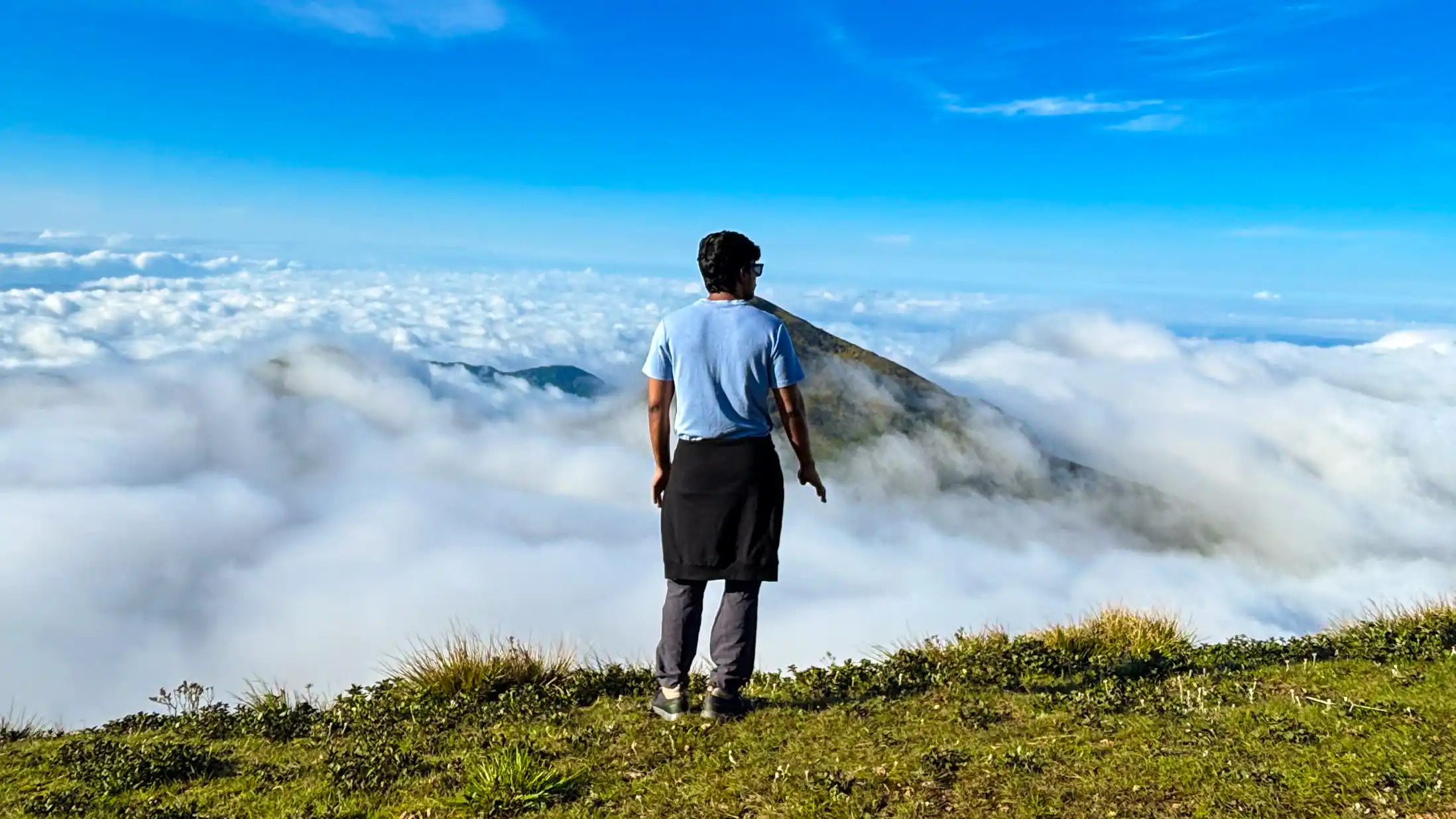
Somewhere between the first ridge and the open grassland, the cloud layer breaks just enough below you. And you realise you're not walking through the weather anymore. You're above it.
That's Meesapulimala at 2,640 metres — South India's second-highest peak and highest trekking point, sitting in the Western Ghats above South India. From the summit, you can see rolling shola grasslands, rhododendron forests, Nilgiri Tahr, rare species, and mountain ranges that seem to go on forever. Every time, the valleys fill with cloud beds and the mist comes up behind the hills, turning everything the colour of fire. People come for the views. They come back for the feeling.
Hiker India is one of Kerala's KFDC-licensed trek operators for Meesapulimala, having successfully completed 190 batches so far, with upcoming batches already scheduled. This guide draws from the experience gained across these treks and covers everything you need to know before planning your journey.
Meesapulimala at a Glance
Meesapulimala, located near Munnar in Kerala, stands at an elevation of 2,640 m (8,661 ft) above sea level. The trek covers approximately 8–10 km round trip and is considered moderately difficult, taking around 6–7 hours to complete. A permit from KFDC is required, and the best time to visit is from September to February. Hiker India, a KFDC-licensed operator, conducts guided Meesapulimala trekking experiences. Meesapulimala is the second-highest peak in South India and the highest trekking point, just behind Anamudi. It sits in the Rajamala range near Munnar and falls under reserved forest — which means you need a KFDC permit to trek it, and you need to go with an authorised operator. Hiker India has been doing exactly this across 190 successful batches.
.webp)
What Actually Is Meesapulimala?
The peak stands at 2,640 metres in the High Ranges of South India, within the Eravikulam National Park buffer zone in Idukki district. It is the second-highest peak in the Western Ghats. The only thing above it here is Anamudi at 2,695 m — which is why trekkers and geography enthusiasts refer to Meesapulimala as the highest trekking peak in South India after Anamudi.
The name itself is Malayalam. Meesa means moustache or whisker, puli means tiger, and mala means mountain. Tiger's whiskers mountain. The story goes that the jagged ridgeline, from a distance, resembles the whiskers of a crouching tiger. Whether you see it or not depends on your imagination, but it's a fitting name either way.
Ecologically, this is important land. The Rajamala-Meesapulimala ridge is core habitat for the Nilgiri Tahr, an endangered mountain ungulate found only in the Western Ghats. The upper slopes are shola grasslands — ancient, fire-resistant ecosystems that feed rivers across Kerala and Tamil Nadu. This isn't just a scenic mountain. It's a watershed.
There's also the Neelakurinji connection. Strobilanthes kunthiana is a flowering shrub that blooms once every twelve years across these slopes, turning the hillsides violet-blue. The last bloom happened in 2018, and the next is expected around 2030. When it returns, the region will witness an extraordinary level of interest from nature lovers and trekkers.
Rhododendron, popularly known as Lali Gurans, is the national flower of Nepal and a symbol of Himalayan wilderness. While most commonly associated with the Himalayas, trekkers can also spot rhododendrons blooming along sections of the Meesapulimala trail. Their vibrant colours add a magical touch to the rolling grasslands and misty hills of the Western Ghats, creating unforgettable scenery during the blooming season.
The peak connects to the Annamalai Hills to the east and the Agasthyamalai range to the south, forming part of the Western Ghats biodiversity corridor — a UNESCO World Heritage landscape.
Permits & Booking: What You Need to Know
Why the Permit Exists?
The KFDC (Kerala Forest Development Corporation) controls access to Meesapulimala because it has to. The ecosystem is sensitive. Uncontrolled foot traffic compacts fragile soils, disrupts grazing routes for wildlife, and disturbs nesting birds on the upper slopes. The permit system caps daily numbers and keeps the trail in a condition where it remains worth experiencing. Without it, the very thing that makes Meesapulimala special would
How KFDC Booking Works?
Slots are date-specific. There's a daily cap. The process is straightforward:
- Check available dates through an authorised operator or KFDC channel.
- Pick your date.
- Submit ID details for all trekkers.
- Get permit confirmation.
- Show up at the KFDC check-in point on trek day.
The permits don't transfer. If you're on the wrong date or don't have one, the gate turns you away. No exceptions and no on-the-spot permits.
Why Most People Book Through Operators?
The logistics of a Meesapulimala trek involve more moving parts than most people expect permit, full-time coordination, jeep transport, accommodation, and guides who know the route in the dark because many treks begin before sunrise.
Working through a licensed operator like Hiker India means all of that is handled.
Hiker India takes care of:
- Permit paperwork.
- KFDC coordination.
- Jeep transport from Munnar.
- Certified local trek leaders.
- Base camp accommodation.
- Meals.
You get to Munnar and everything after that is sorted.
How Early Should You Book?
Weekdays — a week or two out is usually fine.
Weekends and public holidays — three to four weeks minimum.
Peak season slots around Christmas, New Year, and Onam fill fast. Some popular dates sell out within hours.
Don't leave it too late.
Can You Trek Without a Permit?
No. The forest gate checks every trekker. Visitors without valid permits are turned back. There is no workaround.
The Route: How the Trek Actually Goes?
Rhodo Valley Route — The Main Route
This is the route Hiker India operates and the one most permitted trekkers use. It's also the route this guide describes in detail.
Getting There
From Munnar town to the KFDC base camp, the journey covers approximately 25 km one way and takes around 2 hours by jeep. The route passes through beautiful tea plantations and the scenic Silent Valley village, with the landscape gradually changing as the altitude increases.
The jeep ride itself is part of the experience. Long before you've taken your first step, you're already immersed in the mountains.
Base Camp to Summit
The trek moves through distinct zones, and the character of the trail changes at each stage.
The first section takes you through rhododendron forests, where Rhododendron nilagiricum blooms in shades of red and pink between February and April. Under the canopy, the gradient is gentle and comfortable, allowing trekkers to settle into a steady rhythm.
Then the landscape opens into the spectacular Rhodo Valley. Vast grasslands stretch out on all sides, with the ridgeline visible in the distance. This is also where Nilgiri Tahr are frequently spotted grazing peacefully along the slopes.
Landmarks Worth Knowing
Rhodo Mansion
Rhodo Mansion is one of the most iconic landmarks on the Meesapulimala route. From the base camp, trekkers travel approximately 5 km by jeep through rugged mountain terrain to reach Rhodo Mansion.
This marks the beginning of the actual trekking trail and serves as the gateway to the rolling grasslands and ridges that lead to the summit. For many trekkers, this is where the real mountain adventure begins.
Seven Hills
The mid-section of the trek consists of a series of undulating ridges popularly known as the Seven Hills. Each ridge offers progressively better views and serves as a useful mental milestone for trekkers.
Summit Ridge
The final push is the steepest part of the trek. The gradient increases over the last kilometre, tree cover disappears, and the wind becomes stronger. On clear days, visibility extends deep into Tamil Nadu.
This is where the trek truly earns its moderate rating.
What the Terrain Is Actually Like?
The Meesapulimala trek takes you through rolling green hills often covered in mist and clouds. To reach the summit, you'll cross seven beautiful hills, each offering breathtaking views of the Western Ghats.
Most of the trail is gradual and scenic, but two or three steep sections require additional effort. The cool mountain breeze and constantly changing landscapes make the climb enjoyable, and every step becomes increasingly rewarding as you approach the summit.
Jeep Coverage
The jeep journey covers the route from Munnar through Silent Valley village to the KFDC base camp and then further to Rhodo Mansion. The actual trekking trail begins from Rhodo Mansion, and the jeep does not cover any portion of the summit trail.
The Kurangani Route
This route approaches Meesapulimala from the Tamil Nadu side near Theni district. It is longer and more challenging, making it better suited to experienced trekkers.
Access restrictions on this route change periodically depending on forest department regulations, so anyone considering it should verify the latest status before planning.
Hiker India currently does not operate this route.
Wildlife and Flora
Wildlife
Nilgiri Tahr (Nilgiritragus hylocrius) are undoubtedly the stars of the Meesapulimala trek.
Listed as Endangered on the IUCN Red List, these mountain goats are found only in the Western Ghats. On the Meesapulimala trail, they are most commonly seen in the Rhodo Valley and on the upper slopes.
Since most treks begin early in the morning, sightings are frequent, although they can never be guaranteed.
The summit area lies within the buffer zone of Eravikulam National Park, home to the world's largest population of Nilgiri Tahr.
Beyond Tahr, the ridge also supports:
- Nilgiri Pipit
- Indian Blackbird
- Raptors riding the thermals
- Occasionally, the elusive Nilgiri Marten near the shola forests
Responsible Wildlife Viewing
- Stay on the trail.
- Maintain a respectful distance.
- Avoid feeding animals.
- Keep noise levels low near grazing wildlife.
Flora
Three distinct ecological zones define the trek.
Rhododendron Forest
Rhododendron nilagiricum dominates the lower sections and blooms spectacularly between February and April.
High-Altitude Shola Grasslands
These upper slopes are among India's most threatened ecosystems. They support extraordinary biodiversity and serve as the source of several rivers flowing through Kerala and Tamil Nadu.
Shola Patches
These dense montane forests occupy valleys and hollows between grasslands. They are ancient ecosystems that play a vital role in water conservation and support numerous endemic species.
And then there is the famous Neelakurinji (Strobilanthes kunthiana), which blooms once every twelve years, transforming entire hillsides into shades of violet-blue.
The last bloom occurred in 2018, and the next is expected around 2030.
Trekkers are encouraged to follow Leave No Trace principles:
- Carry back all waste.
- Avoid disturbing vegetation.
- Stay on marked trails.
- Never pick flowers or plants.
Difficulty and How to Prepare?
The Honest Assessment
The Meesapulimala trek is generally considered an easy-to-moderate trek, making it suitable for beginners and first-time trekkers.
Most of the route is gradual and easy to walk, with only a few steep climbs. If you have a basic level of fitness and enjoy walking, you can comfortably complete the trek.
The things that push the difficulty up include:
- Early morning starts.
- Summit temperatures that can drop below 5°C during winter.
- A rocky final ascent.
- Strong winds along the open ridge.
- An 8–10 km trek with significant elevation gain.
Fitness Check
If you can comfortably do the following, you're ready:
- Walk 5–6 km without difficulty.
- Climb stairs continuously for 10–15 minutes.
- Walk uphill without knee or joint pain.
Preparation (2–3 Weeks Out)
Walking
Walk 5–7 km, four or five times per week, preferably on inclined terrain.
Stairs
Practice climbing stairs for 10–15 minutes, three or four times per week.
Cardio
Cycling, jogging, and swimming help build endurance.
Strength
Bodyweight exercises like squats and lunges are especially useful because the descent is where unprepared knees suffer the most.
Avoid trying to cram fitness into the last few days. Rest properly before the trek.
What Hiker India's Package Covers?
The meesapulimala trek package is designed around one idea: remove every obstacle between you and the summit.
Permit Handling
Hiker India coordinates all KFDC formalities. You don't have to worry about forest office procedures or paperwork.
Complete Trek Guidance
Trekkers receive detailed information regarding:
- What to pack.
- Weather updates.
- Reporting times.
- Fitness requirements.
- Clothing recommendations.
The support team is available throughout the pre-trek journey to answer questions and provide assistance.
Detailed Instructions
From booking confirmation to reporting time, you'll receive clear instructions so you know exactly what to expect.
Jeep Transport
Transportation from Munnar through Silent Valley village to the KFDC base camp and further to Rhodo Mansion is fully included.
The off-road jeep ride itself is a memorable experience and forms an important part of the adventure.
Guided Trek
Local trek leaders who have completed the route across numerous seasons manage:
- Navigation.
- Safety.
- Group pacing.
- Wildlife interpretation.
Their experience often makes the difference between a good trek and a memorable one.
Accommodation
Camp package participants stay overnight in tents at the base camp. Sleeping bags are provided, allowing trekkers to acclimatise before summit day.
Meals
All meals are included.
The campfire experience the night before the trek is something many participants remember long after the summit.
It's often where a group of strangers becomes a group of friends.
Not Included
Reaching Munnar is your responsibility.
Once you arrive in Munnar, Hiker India takes care of everything else.
Which is the Best Time to Visit Meesapulimala?
- The best time to visit Meesapulimala is from September to February, when the weather is cool, the skies are clear, and visibility is excellent.
- January offers cold conditions with spectacular cloud formations below the summit, while February brings pleasant weather and the beginning of the rhododendron bloom.
- March and April–May are also good months, with comfortable temperatures and blooming wildflowers.
- Although the monsoon season from June to August transforms the landscape into a lush green paradise, heavy rain, mist, and leeches can make trekking challenging.
- September marks the return of clear views and vibrant greenery, while October, November, and December are considered peak months, offering fresh post-monsoon scenery, excellent wildlife sightings, and festive-season charm.
Why Peak Season (October–February) Is What Most People Come For?
Trekking-only participants are usually picked up from Munnar around 4 AM, allowing enough time to reach the trail and experience sunrise from the mountains. Camp package participants are picked up from Munnar at around 10 AM on the previous day and spend the night at the base camp before beginning the summit trek.
During winter, temperature inversions create one of Meesapulimala's most magical sights. Valleys below the summit fill with clouds while the upper slopes remain clear, producing the famous cloud sea that glows golden at sunrise.
At the summit during January and February, temperatures typically range between 4°C and 8°C, though strong winds can make it feel colder. Layering is essential.
Monsoon Season (June–August)
For those who love rain and misty mountains, the monsoon season offers a completely different experience.
The hills become intensely green, clouds drift across the ridges, and the forests feel alive. However, trekkers should expect:
- Slippery trails.
- Thick mist reducing visibility.
- Leeches along certain sections.
Nature lovers often consider this season incredibly rewarding, while those seeking panoramic views may prefer post-monsoon or winter months.
Post-Monsoon (September–October)
The grasslands are at their greenest, waterfalls are flowing, and the air is exceptionally fresh.
September still brings occasional leeches and lingering clouds, but October combines post-monsoon beauty with improving visibility and cooler temperatures.
Many experienced trekkers consider October one of the finest months to visit Meesapulimala.
What to Pack?
Pack for cold temperatures, strong winds, possible rain, and an early start.
Clothing and Footwear
- Trekking shoes with good grip and ankle support.
- Moisture-wicking base layer.
- Fleece or insulated mid-layer.
- Windproof jacket.
- Extra pair of socks.
- Thermal wear during winter.
- Rain poncho or rain jacket.
Safety and Health
- Basic first-aid kit.
- Personal medications.
- Sunscreen.
- Insect repellent.
- Leech socks (recommended during monsoon and post-monsoon).
Hydration and Nutrition
- Minimum 2 litres of water.
- Electrolyte sachets.
- Energy bars.
- Nuts and trail snacks.
Electronics and Documents
- Fully charged phone.
- Power bank.
- Camera or spare battery.
- Government-issued ID.
- Permit copy (provided by Hiker India).
Things People Forget
- Headlamp or torch.
- Backpack rain cover.
- Lip balm.
- Woollen cap.
- Gloves during winter.
What People Actually Say?
Jacob Mathew — Batch 59
Jacob arrived at base camp alone. He didn't know anyone. By the time the campfire got going that evening, he was chatting with trekkers from Kochi, Bengaluru, and Thrissur. "I came for the mountain," he later said. "I didn't expect to leave with people I'd actually stay in touch with." The next morning, he struggled around the Seven Hills section. His trek leader quietly adjusted the group's pace and ensured everyone reached the ridge in time for the sunrise. "It wasn't dramatic," Jacob said. "He just knew what he was doing." Jacob later returned for another Hiker India trek.
Shifa — Batch 47
Shifa had never experienced high-altitude trekking before. Her strongest memory wasn't the summit itself but the moments before reaching it. "We came around a ridge and suddenly there was this wall of pink sky and the whole valley below was white with clouds. I just stopped walking." She described the summit experience as surreal. "You look down and there are clouds. Actual clouds. Below you." Before returning home, she had already booked her next trek.
Altaf — Batch 63
Altaf, an avid wildlife photographer, had trekked across several parts of India. His highlight was encountering a herd of Nilgiri Tahr in the Rhodo Valley early in the morning. The trek leader immediately stopped the group, allowing everyone to watch quietly. "They didn't care we were there," Altaf recalled. "Nothing was staged. They were simply living their lives. It was one of the closest wildlife encounters I've had in years."
Getting to Munnar
By Road
From Kochi
Approximately 130 km away, taking around three to four hours by road. State buses and taxis are readily available.
From Coimbatore
Roughly 150 km via Marayoor, with travel times ranging between three-and-a-half and four-and-a-half hours.
From Thrissur and Ernakulam
Both private and KSRTC buses connect these cities to Munnar.
By Train
The nearest major railway station is Aluva, located around 110 km from Munnar.
From Aluva, taxis and buses typically take around three hours to reach Munnar.
Aluva has excellent connectivity to:
- Kochi
- Chennai
- Bengaluru
- Mumbai Delhi
By Flight
The nearest airport is Cochin International Airport (COK), located approximately 120 km from Munnar.
Travel time from the airport to Munnar ranges between three and three-and-a-half hours, depending on traffic conditions.
For dates, availability, and bookings, contact Hiker India.
Frequently Asked Questions
Is the Meesapulimala trek suitable for beginners?
Yes. The Meesapulimala trek is one of the most beginner-friendly treks in South India and is highly recommended for first-time trekkers. Every year, thousands of beginners successfully complete the trek, including children above six years of age trekking alongside their families. You don't need previous trekking experience to participate. A basic level of fitness and simple preparation, such as regular walking or climbing stairs, will help you enjoy the experience more comfortably. With expert guidance and a steady pace, the trek is achievable for most people who enjoy outdoor activities and are ready for an adventure.
Do I need a permit to trek Meesapulimala?
Yes. A KFDC permit is mandatory. Without a valid permit, entry is not allowed. Permits are date-specific, obtained in advance, and non-transferable. Hiker India handles all permit coordination for trekkers who book through them.
What is the best time to visit Meesapulimala?
October through February offers the best overall experience, with clear skies, cold temperatures, cloud sea formations, and excellent wildlife visibility. January and February are particularly popular for sunrise views and winter conditions. March is pleasant and slightly warmer, while September and October provide lush post-monsoon landscapes.
How difficult is the Meesapulimala trek?
The trek is generally considered easy to moderate. Trekkers cover around 8–10 km over 6–7 hours, crossing forests, grasslands, and a few steep sections before reaching the summit. While the route is beginner-friendly, preparation and a reasonable fitness level make the experience much more enjoyable.
What is the elevation of Meesapulimala?
Meesapulimala stands at 2,640 metres (8,661 feet) above sea level, making it the second-highest peak and the highest trekking point in South India after Anamudi.
Can I trek Meesapulimala without a guide?
No. The KFDC permit system requires trekkers to visit with an authorised operator. Independent trekking is not permitted in this region. Beyond regulations, experienced guides greatly enhance safety and help trekkers navigate changing weather and wildlife encounters.
What should I pack for the Meesapulimala trek?
Essential items include: Trekking shoes with good grip. Warm layered clothing. Windproof jacket. Headlamp or torch. At least 2 litres of water. Energy bars and electrolytes. Power bank. Government-issued ID. Leech socks during the monsoon and post-monsoon months.
How far is Meesapulimala from Munnar?
The KFDC base camp is located approximately 25 km from Munnar town, and the journey takes around 2 hours by jeep. From the base camp, trekkers continue for another 5 km by jeep to Rhodo Mansion, which marks the beginning of the actual trekking trail.
Is the Meesapulimala trek open during monsoon?
Yes. The trek is generally open during the monsoon season, subject to weather conditions and forest department guidelines. Monsoon transforms the hills into lush green landscapes filled with drifting clouds and mist. However, trekkers should be prepared for slippery paths, occasional leeches, and reduced visibility. For those who enjoy rain and dramatic mountain scenery, the monsoon season can be incredibly rewarding.
What does Hiker India's package include?
The package includes: KFDC permits. Jeep transportation from Munnar. Tent stay at the base camp (camp package). Sleeping bags. All meals. Guided trekking with experienced trek leaders. Once you arrive in Munnar, Hiker India takes care of the rest, ensuring a hassle-free experience.
What is the Rhodo Valley route?
The Rhodo Valley route is the primary and most popular route to Meesapulimala. It is accessed from Munnar via the KFDC base camp and Rhodo Mansion, passing through rhododendron forests, rolling grasslands, and the famous Seven Hills before reaching the summit. This is the route used by Hiker India for all its Meesapulimala batches.
Are Nilgiri Tahr sightings common?
Yes.Most Hiker India groups across 190 successful batches have reported Nilgiri Tahr sightings, especially around the Rhodo Valley and upper slopes. Although sightings can never be guaranteed, the chances are genuinely high, particularly during early morning hours.
The Mountain Is Ready
Meesapulimala doesn't have the crowd density of Kedarnath or the brand recognition of the Himalayan circuits. What it offers instead is something increasingly rare — genuine wilderness at an elevation that most people can comfortably reach.
Standing at 2,640 metres above sea level, watching the sunrise over the Western Ghats while clouds drift beneath your feet, is an experience that stays with you long after the trek ends.
And it's an experience Hiker India has been delivering consistently across 190 successful batches, with many more upcoming groups already scheduled. The permit system exists for a reason.
It protects the fragile ecosystem and ensures the trail remains worth experiencing for generations to come. Booking through Hiker India means the permits are sorted, the transport is arranged, experienced trek leaders are ready, and all you need to do is enjoy the journey.
The Next Batch Is Forming If Meesapulimala has been on your bucket list, don't wait until the slots are gone. Book your Meesapulimala trek with Hiker India and experience South India's highest trekking peak the way it was meant to be explored.
Hiker India is a KFDC-licensed trekking operator based in Kerala. All Meesapulimala treks are conducted with valid permits and experienced local trek leaders.
For batch dates, bookings, and enquiries, visit the Hiker India Contact Page or get in touch with the team directly.